Henk Dop: Namibia Trip Report 2005
Sunday 24 April: Sesriem Campsite - Naukluft Campsite; 183 km
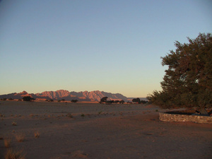
We get up at 0600, just as the moon is setting over the dunes in the West, and a few dozen cars are queuing up for the early morning dash down to Sossusvlei. Not us this time. The girls have been promised that a replacement car would be brought down to Sesriem around noon (and had also been told that they would be held liable for most of the damage, as could be expected), so we ask them to come along for a visit to the Sesriem canyon a few kilometres away.
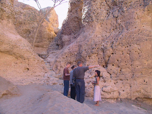
Sesriem canyon offers a fine view into the geology of this area, and the vast amounts of water that must have once flowed around here, eroding away a full kilometre and a half of former mountains. Here in this narrow and roughly 15 m deep canyon, the present Sesriem River is now eating a path down into its former bed, exposing various layers in which the abundance or lack of water of any given period can be gauged from the size of the pebbles and rocks that the river had deposited. The girls are dropped off at the camp's office, we do the goodbye hugs and kisses and quickly find ourselves on the C19 towards Solitaire. To our right are now the Naukluftberge, to our left strangely contorted hills mixed with patches of Namib orange and strips of struggling vegetation.
Suddenly we find ourselves in the midst of a large herd of Springbok, they seem to be all around us. Then we descend down into the broad trough in which lies Solitaire, little more than a fuel station, a shop and a restcamp, yet indicated on each and every map of Namibia. Their coffee and apple pie are once again superb, and we also don't fail to buy a loaf of the famous Solitaire bread en some home-made boerewors.
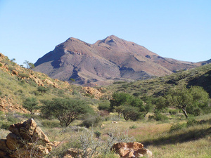
We now turn right on the C14, winding its way between the Rantberge and the Naukluft Berge, coming to Büllsport, one of the older farms in Namibia and a pleasant German bastion where Marike and I had spent a couple of nights in 2001. Instead, we now here turn right onto the D854 for some 15 km to get to the entrance of the Naukluft section of the Namib/Naukluft Park. The mountains look high and steep, one can well imagine that they are indeed a paradise for the hard-core hikers who can even go on an eight-day trail around here.
After the gate it's another 10 km to get to the Park office, a narrow path through flowers and bushes that still maintain some of their summertime glory, crossing numerous shallow dry riverbeds. We get to the office around 1300 for a most friendly welcome, the receptionist is wearing a 'Vote Pohamba' T-shirt (Hifekepunye Pohamba, Namibia's newly elected president and successor to Sam Nujoma). I delight in the display of Schutztruppe memorabilia, photo's as well as rusty hardware. There's also an ancient BP gasoline pump on display, obviously lovingly restored. We buy firewood, are warned about the peskiness of the local Baboons, and told to proceed to campsite number 6. On our way there we pass the ornate iron cross that marks the grave of a Schutztruppe Reiter (cavalryman). He may have died a long way from home, but surely got a superb final resting place in return.
Campsite nr. 6 turns out to be obviously the finest site of the dozen or so in 'Koedoesrus Kamp Camp' (Kudu's Rest Camp Camp') as the sign reads. Secluded, shady, right down by a dry riverbed, spacious and spotlessly clean with the dirt neatly scraped. We settle down for a bit of rest, I play around with the tree book, and Marike and I then head out for some productive birding towards 1530. The sun sets behind the mountains well before 1700, so Maarten lights an early fire for a braai of Solitaire boerewors while the Rock Dassies around us do their habitual sunset screaming. The night is delightfully fresh.
Monday 25 April: Naukluft Park; 11 km
We grant ourselves the luxury of getting up at 0700, and head out onto the Naukluft trail after a breakfast of Solitaire bread. We'll just be doing a small part of the trail, all 7 hours of it is more for the true enthusiasts. So we set out at a gentle pace, generally following the dry riverbed upstream, spotting a Black Eagle along the way. There are some steep climbs, twists and turn, until we come to the first pools, an idyllic site with numerous small waterfalls in the shade of a cliff-face where Kokerbome and Fig trees find a tenuous hold. From here on, however, the path becomes to narrow and steep for my vertigo, so we turn back.
As we approach camp again, a patch of flowers attracts my attention, and suddenly we see three Klipspringers, two adults and a young, no more than some 75 meters away, and initially unconcerned about our presence. After a few minutes they decide to move off anyway, and we can see them nimbly jumping over the rocks, seemingly without any effort, until they disappear from our view over a ridge. Klipspringer - a true favourite, so much hoped to be able to see around here, and then such an extended sight ...
Coffee at camp around 1100, time to make good use of the heat of the day by doing some laundry. Towards 1400 we head out for the Olive Trail after a brief stop at the office where an error in our camping permit for the Northern Section of the Namib/Naukluft is corrected. The receptionist, now in uniform, delights in our Klipspringers. The Olive Trail is an easier walk, it largely follows a broad riverbed and the Naukluft 4x4 trail. This must indeed be a challenging trail, but when Maarten exclaims in one section 'You can't do this with a car!', we have to reply that we did just such stretches in the Richtersveld in South Africa in 2001. Quite a fond memory, if rather frightening at the time! As the sun sets over the higher peaks around us, a fine play of light-rays forms in many parts of the valley. As we climb up a rather steep passage, we get our first glimpses of the Baboons we've been warned about. Maarten does what has become his instinct at the mere mention of the word 'Baboon', picks up a rock and scores a near-miss. The critters hurry off without giving him a chance at a second shot. When we return to camp, a lone Klipspringer is browsing around near the Reiter's grave, we prepare potjiekos from various dried sausages, rice and kidney beans.
From here on, things steadily become drier and drier. A pair of Swiss cyclists, easily recognised as such by the flags on their bikes, laboriously work their way up to Aus in the fierce midday sun. Signs warn of crossing feral horses, an amazing population that somehow managed to thrive around here after having escaped from their Schutztruppe masters. We don't get to see any, just a lone Oryx in the distance. Work is being carried out on the railway to Lüderitz, it's obviously being completely renewed, and the works throw up huge clouds of dust.
Towards Lüderitz, signs warn of shifting sands, and a brisk wind indeed blows a steady flow over the road, with work crews constantly combating the moving desert. Alongside the road, dunes cover whole stretches of the former railway line, as well as a derelict station house. On our left, we pass the ghost city town of Kolmanskop, a century ago the epicentre of the free-for-all diamond boom until De Beers took over and the Sperrgebiet (restricted area) was created.
We enter Lüderitz around 1300, fill up, and drive around town. That takes little more than minutes in any direction: Lüderitz is just a small town, its architecture a German colonial anachronism, its only claim to fame being that it was where the first German (and highly dubious) colonial acquisition of land took place in 1883 by Mr. Lüderitz (first known as Angra Pequena, it was re-named into Lüderitzbucht, a settlement so remote and dry that, at first, drinking water had to be shipped in from the Cape! - see also www.namibweb.com/luderitz.htm). New initiatives, like an expansion of the port and fisheries industries, have sought to breathe new life into the local economy. Unfortunately, Namibian fisheries are now falling upon hard times as rising fuel costs, decreasing demands for its mainstay species of Hake and a strong Rand erode into their competitiveness.
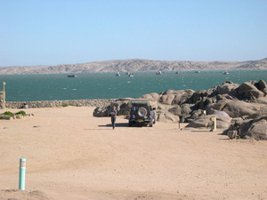
Today's destination is Shark island, a former island now linked to the mainland by a broad causeway. It was to Shark Island that captive Nama fighters and their relatives were interned during and after the 1904-1907 Nama uprising, causing them to die in their hundreds from the harsh conditions on these cold and windswept rocks, until Oberstleutnant von Estorff's courageous personal intervention to move them onto the mainland. A small memorial marks their suffering. We check in at the campsite, try (and largely fail) to find a slightly sheltered spot, and have a challenging time setting up our tents. 'It's a bit windy now, but the wind will settle around 7 tonight', said the gatekeeper. The man must have been suffering from terminal optimism.
We stroll around town and the newly developed shorefront shopping mall, and quickly come to the conclusion that our plans for the next morning to go on a boat ride on the schooner 'Sedina' to see Sealions and Jackass Penguin on Halifax Island are best dropped: with this wind, I'd be sure to get violently seasick. As we continue through the town, I see that the shoe-store sells Namibian hand-made Sealion leather shoes, and buy a pair of nice veldskoene (field shoes). Back at the campsite, we get some great views of African Black Oystercatchers, and end up cooking our dinner as well as eating it in the shelter of the field kitchen, as the wind remains both fierce and cold.